


Ferrata de la Mulatica (Andilla)
Very beautiful ferrata with a different stone kinds from the usual of the Valencian Ferratas and equipment in optimal condition.
| Name | Mulatica Ferrata |
| Province | Valencia |
| Nearest population | Andilla |
| Difficulty | k3 (somewhat difficult) |
| Best Season | All year around. |
| Escapes | No |
| State of the Ferrata | Good (2019) |
| Crashes | Yes, in several sections of the ferrata pay attention to the last step before the end. |
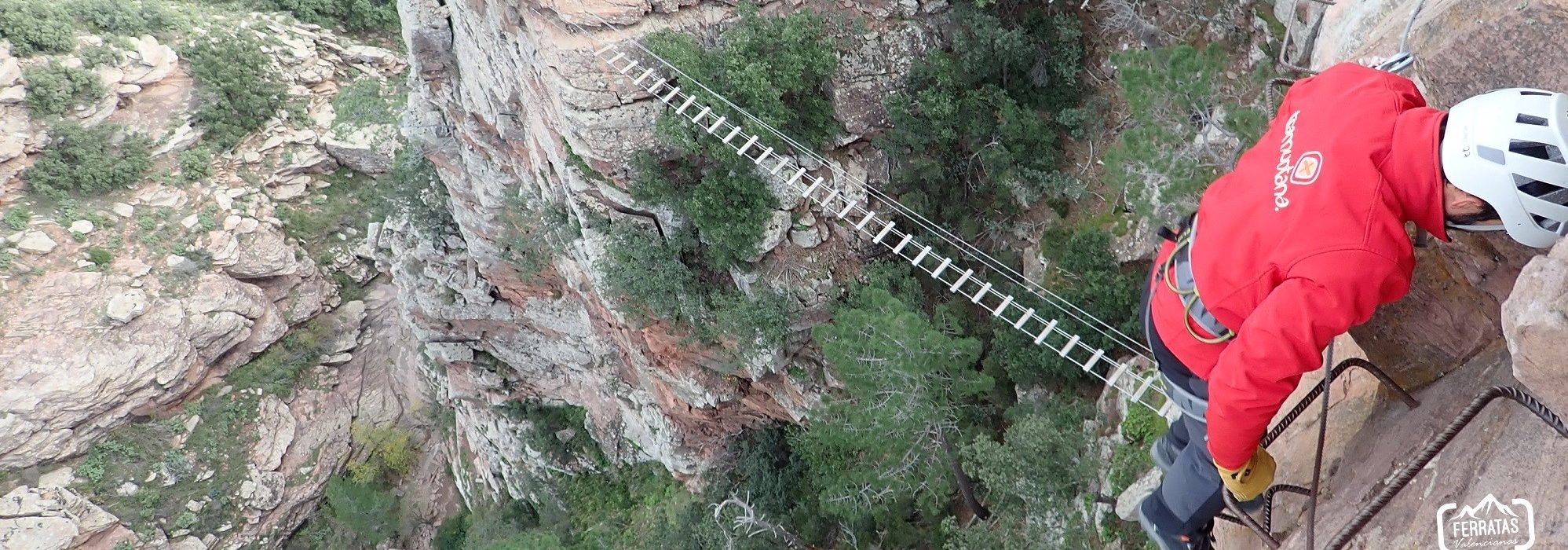
| Bridge | Yes, one of wooden walkways |
| Zip Line | No. |
| Rappel | No |
| Other facilities | No |
| Approach time | 10 minutes |
| Ascent time | 40 minutes |
| Return time | 20 minutes |
| Total route (approach + ferrata + return) | 2300 meters |
| Total height equipped section | 150 meters |
| Total activity level (ferrata + approach + return) | 220 meters |
| Remarks | The area is very pretty with rodeno stone material. |
Approach by car : We drive to the town of Andilla so once in town follow the road through the access into town (CV-341 road) and at its end we found the municipality old laundry area and the Fronton sport area. Just before going up to the church, a road takes down on the right handside that indicates “Fuente del señor”, a medieval route, and Mulatica ferrata and the GR10 track signs. Then this road becomes a ground track after passing the pool and sports area, so yopu will find indications to the ferrata all the way. Then we will pass through a fountain with a trough in a bend, but continue along the main track until reaching the recreational area. It is easy to identify because there are signs, a small shelter by a crossroads to the right handside and another shelter facility with a porch area with benches and tables on the left handside. We can leave the car in either of the two shelters. More or less from the town of Andilla there are 3 km.
Approach to the beginning ferrata :
From the car parking follow the track that passes in front of the shelter (the one above),then we leave the recreational area (on the left) and the track becomes a path so we see the ravine on the right (there are also some indications). We continue along the path to the same ravine so the ferrata is about 100 meters inside, and we have to save a couple of small climbs and more or less water depending to the season. And the ferrata appears on the right hand side.
Description of the Ferrata : The ferrata in general is quite vertical, beginning with a section of 40 continuous vertical meters and with more or less collapse, as the staples progress are placed in some diagonal sections making the progression somewhat difficult. After the 1st vertical section we find a horizontal section that leads us to a second vertical and more collapsed section, after about 70 vertical meters we arrive at the well-equipped wooden footbridge. It will leave us at the foot of the wall, and again a vertical section so this is the most difficult part of the ferrata, with extra-plung sections, with diagonal progression sections and a final step forcing us to squat, and after to saving this point we have reached the end of the ferrata, with extraordinary views on the valley bellow.
Return : When the ferrata ends the path is on the left so there are indications of how to descent (the path is on the right if we look at the valley). The path is quite steepy and goes down towards the ravine, and after about 5 minutes of descent steeps it leaves us in the same ravine a little above the beginning of the ferrata. Then go downstream, then left and we already arrive at the beginning of the ferrata, from here we only have to retake the starting path.