


Ferrata Dos Aguas (Dos Aguas)
Ferrata perfectly complemented together with the canyoning activity. Everything surrounded into a very interesting area with great mountain environment and extraordinary geological formations. Check out the state of equipement.
| Name | Ferrata de Dos Aguas. |
| Province | Valencia |
| Nearest town | Dos Aguas |
| Difficulty | k3 (somewhat difficult) |
| Best season | All year around. There are no restrictions |
| Escape points | Yes, in the middle of the ferrata there is an escape point to the right handside |
| State of the Ferrata | Deficient (2019) |
| Crashes | Yes |
| Bridges | Yes. 15 meter Tibetan bridge |
| Zip Lines | No |
| Rappel | Yes. Mandatory, recommended to carry a 70 meter rope minimum. There are two rappels within the possibility of splitting the first into two rappels (19 and 14 meters), but the anchors of the fraction rope are not suitable. First rappel of 33 meters and 2nd rappel of 20 meters long. |
| Other facilities | No |
| Approach time | 25 Minutes |
| Ascent time | 45 minutes |
| Return time | 45 minutes + rappel |
| Total route (approach + ferrata + return) | 1600 meters |
| Total height equipped section | 110 meters |
| Total difference in heights (ferrata + approach + return) | 240 meters |
| Remarks | The cable has been changed of the ferrata in almost all the way, but there are some sections still the old one or just rope and there are several steps that are bent and they are quite thin. |
Approach by car :
We arrive at the town of Dos Aguas and we have to drive along the CV-435 towards Carlet, after passing the last houses of the town at the first crossing that goes to our left handside (the access shows a very tight curve) an asphalted road goes up next to some villas.
We continue driving along this road and in about 200 meters, so after passing a couple of houses on the left handside we will find a first house on the right handside, just before this we will see a stream of stones and this is the access to the via ferrata, but we will leave the car a little later by the end of the ravine from where to return back after finishing the activity. The car park is quite small, fits only 2 vehicles, and it is in a bend. It can be used as a reference because in the immediate vicinity we can see a water raft and a small ditch where it collects the water from the ravine.
Best leave the car at this point, go on the asphalt path to the villa locate by the stream.
Approach ferrata :
From the stream we have to going up by its sides, sometimes crossing from one side to the other. The road is quite broken and not easy to follow, but we have to go to the mountain and then we see the ferrata at its foot.
Description of the Ferrata :
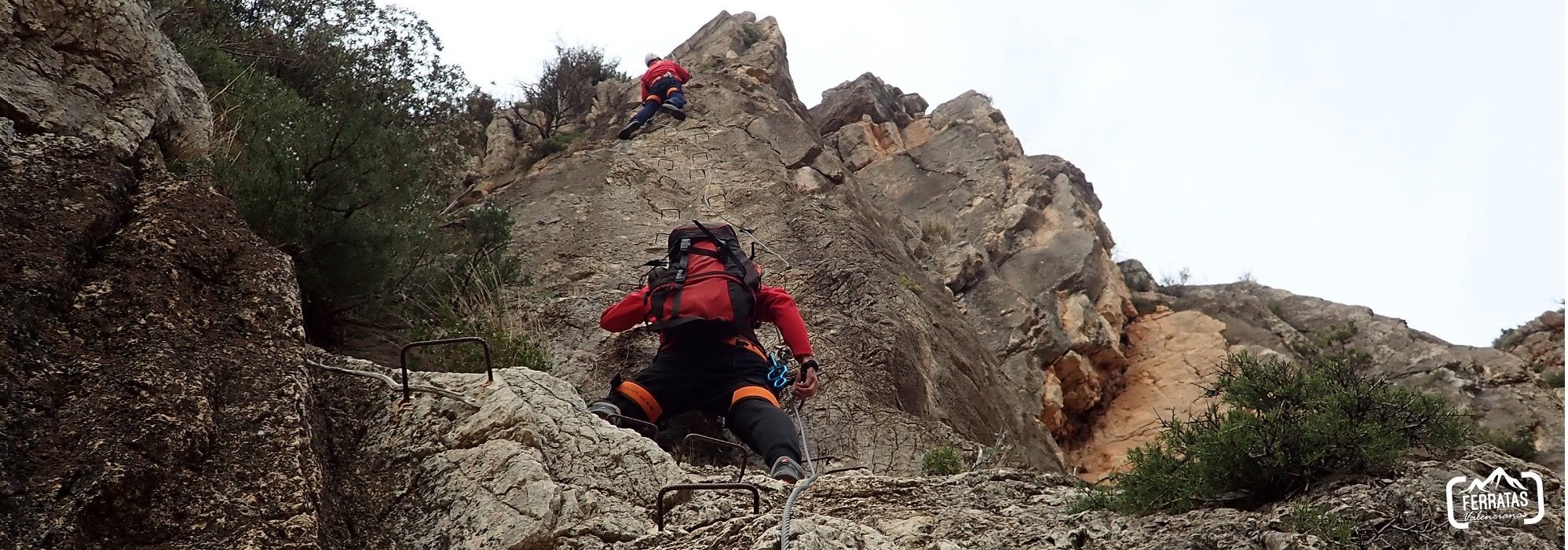
It is a fairly complete ferrata with different sections, although the state of the installation is not adequate, it can make you feel "disturbing".
The ferrata begins with a vertical section that gains height quickly and takes us almost directly to a Tibetan bridge, we cross it and now a small horizontal section with rope life cable to achieve. It leaves us again into another wall and we make a vertical section of 15 meters, again another horizontal section and now begins a fairly long vertical section where it is seen that the state of the ferrata is not the most appropriate, with fairly bent steps, cable just few millimeters thin, some loose step, but all very vertical. About 40 meters higher the ferrata tends to the left handside lying a bit. After about 15 meters we reach the final part of the cable. The ferrata continues, now without cable, all the way before a small climb and a little higher up some staples that help you climbing this wall section. At the end of this climb we arrive at an area with a chain. The views of the surroundings and the town are spectacular.
Return : From the meeting point we have to continue climbing to the left handside so a loneley pine tree about 400 meters away will be our visual reference. The path is more or less marked and there are some other milestones or landmarks, and after passing the pine tree we continue climbing to the right handside, and about 200 meters ahead we reach the top of the mountain which matches with a small ridge from here we have to go down on the crest rope following the milestones or landmarks, which lead us after a beautiful descent to the bed of the ravine. We continue to the left handside and after about 10 minutes we reach the 1st rappel where the meeting point is on the left handside. The rappel is quite simple and not excessively vertical. So after this we will continue going down and we will find some odd and fixed rope, the ravine narrows until reaching the 2nd rappel, the meeting point on the left, from here you can see the town and even the car parking. Once the 2nd rappel is finished, just 200 meters away, we arrive at the parking lot.
We arrive at the town of Dos Aguas and we have to drive along the CV-435 towards Carlet, after passing the last houses of the town at the first crossing that goes to our left handside (the access shows a very tight curve) an asphalted road goes up next to some villas.
We continue driving along this road and in about 200 meters, so after passing a couple of houses on the left handside we will find a first house on the right handside, just before this we will see a stream of stones and this is the access to the via ferrata, but we will leave the car a little later by the end of the ravine from where to return back after finishing the activity. The car park is quite small, fits only 2 vehicles, and it is in a bend. It can be used as a reference because in the immediate vicinity we can see a water raft and a small ditch where it collects the water from the ravine.
Best leave the car at this point, go on the asphalt path to the villa locate by the stream.
Approach ferrata :
From the stream we have to going up by its sides, sometimes crossing from one side to the other. The road is quite broken and not easy to follow, but we have to go to the mountain and then we see the ferrata at its foot.
Description of the Ferrata :
It is a fairly complete ferrata with different sections, although the state of the installation is not adequate, it can make you feel "disturbing".
The ferrata begins with a vertical section that gains height quickly and takes us almost directly to a Tibetan bridge, we cross it and now a small horizontal section with rope life cable to achieve. It leaves us again into another wall and we make a vertical section of 15 meters, again another horizontal section and now begins a fairly long vertical section where it is seen that the state of the ferrata is not the most appropriate, with fairly bent steps, cable just few millimeters thin, some loose step, but all very vertical. About 40 meters higher the ferrata tends to the left handside lying a bit. After about 15 meters we reach the final part of the cable. The ferrata continues, now without cable, all the way before a small climb and a little higher up some staples that help you climbing this wall section. At the end of this climb we arrive at an area with a chain. The views of the surroundings and the town are spectacular.
Return : From the meeting point we have to continue climbing to the left handside so a loneley pine tree about 400 meters away will be our visual reference. The path is more or less marked and there are some other milestones or landmarks, and after passing the pine tree we continue climbing to the right handside, and about 200 meters ahead we reach the top of the mountain which matches with a small ridge from here we have to go down on the crest rope following the milestones or landmarks, which lead us after a beautiful descent to the bed of the ravine. We continue to the left handside and after about 10 minutes we reach the 1st rappel where the meeting point is on the left handside. The rappel is quite simple and not excessively vertical. So after this we will continue going down and we will find some odd and fixed rope, the ravine narrows until reaching the 2nd rappel, the meeting point on the left, from here you can see the town and even the car parking. Once the 2nd rappel is finished, just 200 meters away, we arrive at the parking lot.